How AI could help scientists spot ‘ultra-emission’ methane plumes faster—from space
Reducing leaks of the potent greenhouse gas could alleviate global warming by as much as 0.3 degrees Celsius over the next two decades.
Reducing damaging “ultra-emission” methane leaks could soon become much easier–thanks to a new, open-source tool that combines machine learning and orbital data from multiple satellites, including one attached to the International Space Station.
Methane emissions originate anywhere food and plant matter decompose without oxygen, such as marshes, landfills, fossil fuel plants—and yes, cow farms. They are also infamous for their dramatic effect on air quality. Although capable of lingering in the atmosphere for just 7 to 12 years compared to CO2’s centuries-long lifespan, the gas is still an estimated 80 times more effective at retaining heat. Immediately reducing its production is integral to stave off climate collapse’s most dire short-term consequences—cutting emissions by 45 percent by 2030, for example, could shave off around 0.3 degrees Celsius from the planet’s rising temperature average over the next twenty years.
[Related: Turkmenistan’s gas fields emit loads of methane.]
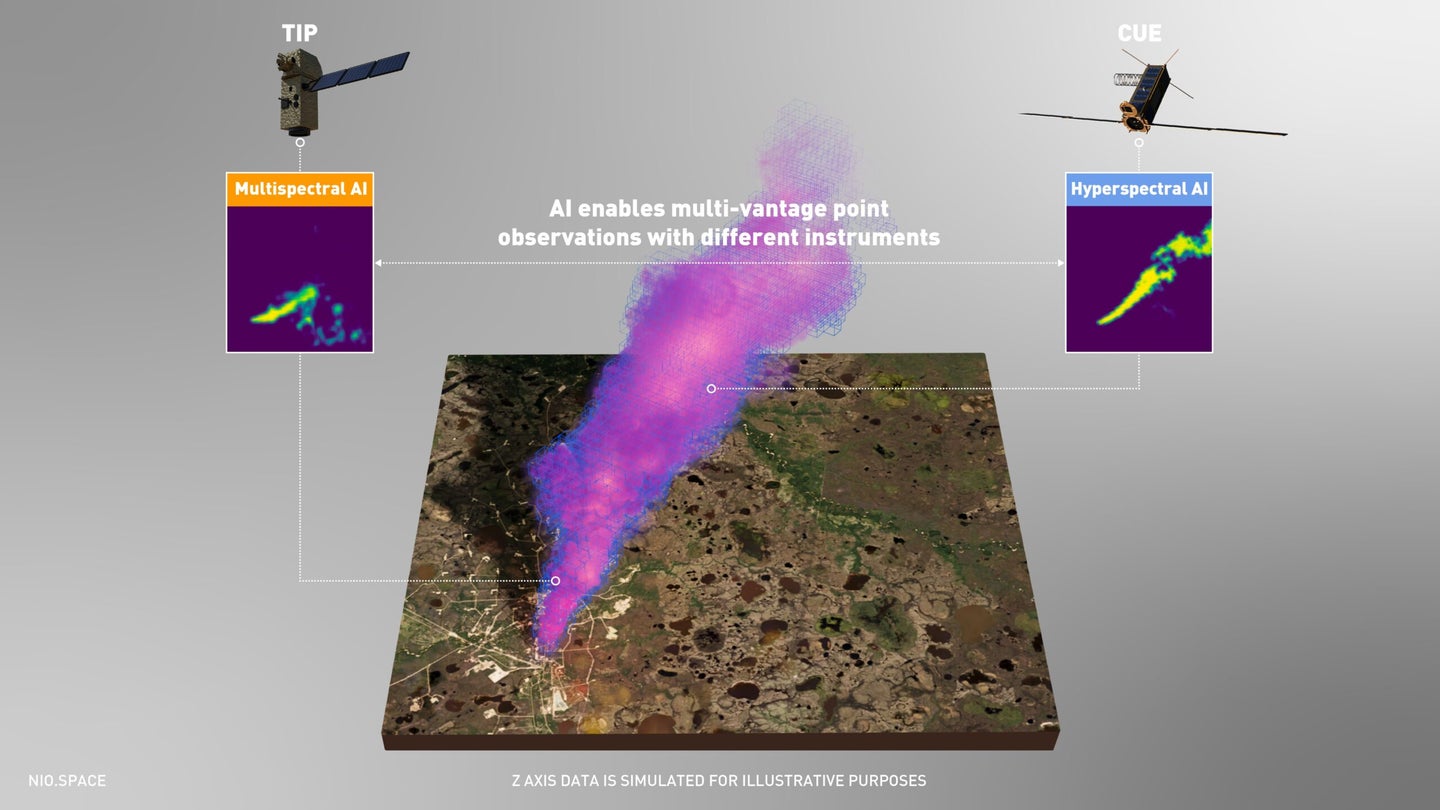
Unfortunately, it’s often difficult for aerial imaging to precisely map real time concentrations of methane emissions. For one thing, plumes from so-called “ultra-emission” events like oil rig and natural gas pipeline malfunctions (see: Turkmenistan) are invisible to human eyes, as well as most satellites’ multispectral near-infrared wavelength sensors. And what aerial data is collected is often thrown off by spectral noise, requiring manual parsing to accurately locate the methane leaks.
A University of Oxford team working alongside Trillium Technologies’ NIO.space has developed a new, open-source tool powered by machine learning that can identify methane clouds using much narrower hyperspectral bands of satellite imaging data. These bands, while more specific, produce much more vast quantities of data—which is where artificial intelligence training comes in handy.
The project is detailed in new research published in Nature Scientific Reports by a team at the University of Oxford, alongside a recent university profile. To train their model, engineers fed it a total of 167,825 hyperspectral image tiles—each roughly 0.66 square miles—generated by NASA’s Airborne Visible/Infrared Imaging Spectrometer (AVIRIS) satellite while orbiting the Four Corners region of the US. The model was subsequently trained using additional orbital monitors, including NASA’s hyperspectral EMIT sensor currently aboard the International Space Station.
The team’s current model is roughly 21.5 percent more accurate at identifying methane plumes than the existing top tool, while simultaneously providing nearly 42 percent fewer false detection errors compared to the same industry standard. According to researchers, there’s no reason to believe those numbers won’t improve over time.
[Related: New satellites can pinpoint methane leaks to help us beat climate change.]
“What makes this research particularly exciting and relevant is the fact that many more hyperspectral satellites are due to be deployed in the coming years, including from ESA, NASA, and the private sector,” Vít Růžička, lead researcher and a University of Oxford doctoral candidate in the department of computer science, said during a recent university profile. As this satellite network expands, Růžička believes researchers and environmental watchdogs will soon gain an ability to automatically, accurately detect methane plume events anywhere in the world.
These new techniques could soon enable independent, globally-collaborated identification of greenhouse gas production and leakage issues—not just for methane, but many other major pollutants. The tool currently utilizes already collected geospatial data, and is not able to currently provide real-time analysis using orbital satellite sensors. In the University of Oxford’s recent announcement, however, research project supervisor Andrew Markham adds that the team’s long-term goal is to run their programs through satellites’ onboard computers, thus “making instant detection a reality.”
